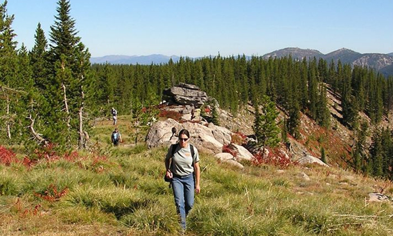


- Missoula offers a plethora of great hikes within minutes of the city center.
- Explore Rattlesnake Recreation and Wilderness Area for both short and long hikes.
- Bag a peak in a day by hiking St. Mary Peak.
- Blodgett Canyon offers some of the best hikes in the area.
Overview
Missoula's prime location gives you easy access to hiking and backpacking in the beautiful Bitterroot Mountains, on Mt. Sentinel and Mt. Jumbo, in Rattlesnake Wilderness Area or in one of the three recreation areas. And those are just the options found in town.
Missoula hiking trails allow you to see big game, fish along some of the most pristine rivers found in the west, and have a true wilderness experience.
Mt. Sentinel is Missoula's mountain and the place to be for Missoula hiking. Marked with a large concrete “M,” it offers the easiest trail access and a moderately strenuous hike right in the heart of Missoula. The views of Missoula Valley can't be beat from the “M” or the summit.
Trailhead: Located right behind the University of Montana's football stadium on Campus Drive. Trailhead is well marked and offers a decent size parking lot.
- Distance-3/4 of a mile to the “M” or 1 and 3/4 of a mile to the summit. If you don't want to retrace your steps down the mountain, take the Crazy Canyon Trail into Pattee Canyon or the Hellgate Canyon Trail which links to the Kim Williams Trail taking you back into Missoula.
- Average Time of Hike- It takes about 20 minutes to reach the “M” and an hour to reach the summit, one way, depending on your fitness level.
- Elevation Gain-620 ft
- Difficulty- Due to the steepness of this trail it is mildly strenuous.
- Trail Type- Out and back trail with switchbacks.
Mt. Jumbo
Mt. Sentinel's sister peak to the north, features an “L” for Loyola high school. This steep hike is barely a mile, but it is sure to get the heart pumping and the sweat flowing, as there are fewer switchbacks to help with the climb.
The northern portion of Mt. Jumbo, above the “L,” is closed in the winter to protect the herd of elk that call the mountain home. Amazing views of the Rattlesnake Wilderness will greet you at the “L.” You have a couple of trails to choose from, non will be as crowded as the “M” trail.
Trailhead: There are two access points to Mt. Jumbo. From Van Buren Avenue in the Lower Rattlesnake take a right on Cherry St. to reach the “L” trail. To reach the Saddle Trail, continue on Van Buren for two miles and turn right at Lincoln Hills. The trailhead is at the end of the paved road.
- Distance-The “L” trail is 2/3 mile. Or you can hike to the saddle, 1.1 miles.
- Average Time of Hike- At least 20 to 30 minutes to the “L.”
- Elevation Gain- 500 ft
- Trail Type- Out and back with few switchbacks.
Waterworks Hill
Waterworks Hill is a dog friendly hike along a treeless ridge. In the spring, the wildflowers paint the hill with multitudes of color. This is a great leisurely hike that rewards you with a nice view of Missoula Valley. A great option for Missoula hiking.
Trailhead: From the intersection of Broadway and Madison, in downtown Missoula, drive north on Madison to Greenough Drive. Take the first left after crossing I-90 and continue up the road to the signed trailhead.
- Distance- The Cherry Gulch loop is 2.2 miles round trip.
- Average Time of Hike- Roughly an hour or less.
- Elevation Gain- 450 ft
- Difficulty- Fairly easy with a gradual elevation gain.
- Trail Type- Loop
Rattlesnake Wilderness and Recreation Area Hikes
The Rattlesnake, as it is commonly referred to, is only 4 miles outside of Missoula. There is an abundance of short trails that loop through the recreation area for great, quick hikes. Just check out the map on the trailhead and pick a route. Listed below are some of the longer, more strenuous hikes into the Wilderness Area, great for a full hard day of hiking or for an overnight backpacking trip.
Sawmill Gulch to Overlook
You don't have to hike for hours to reach this scenic 4, 915 ft overlook. The trail winds through a thick coniferous forest before opening up to views of the Rattlesnake Wilderness to the north.
Trailhead: From Missoula take Van Buren east and drive 4.5 miles up Rattlesnake Dr to the main trailhead. Trail access is from the main trailhead.
- Distance- 4 miles
- Average Time of Hike- 2 hours
- Elevation Gain- 1,100 ft
- Difficulty- Easy to moderate
- Trail Type- Loop
Curry Gulch Trail to Curry Cabin
This is a moderately easy hike that rewards you with a bit of history before you turn around. The Curry Cabin is an old log cabin with multiple rooms. There are also two other log structures to explore.
Trailhead: From Missoula take Van Buren east and drive 4.5 miles up Rattlesnake Dr to the main trailhead. Follows the main trail then head up through Sawmill Gulch and Curry Gulch.
- Distance- 4.8 miles total
- Average Time of Hike- 2.5 hours
- Elevation Gain- 400 ft
- Difficulty- Easy to moderate
- Trail Type- Out and back
Rattlesnake Main Travel Corridor
This trail runs parallel to Rattlesnake Creek along a wide path, that actually used to be an old farm/logging road. Most trails in Rattlesnake merge with this main corridor at one point. It can be crowded.
Trailhead: From Missoula take Van Buren east and drive 4.5 miles up Rattlesnake Dr to the main trailhead. This trail begins at the Sawmill Gulch Road just west of Rattlesnake Dr.
- Distance- This hike is 15 miles to the end of the road, but many trails intersect, leaving you multiple options.
- Average Time of Hike- Varies according to the route you choose.
- Elevation Gain- 1,248 ft
- Difficulty- Easy
- Trail Type- Out and back or loop to one of the intersecting trails.
Spring Gulch/ Stewart Peak Trail
Take a day and bag a peak, Stuart Peak is 7,960 ft and one of the highest peaks in the Rattlesnake. This hike can be strenuous but rewards you with views of the Missoula Valley and surrounding peaks. Bring lots of water for this long hike.
Trailhead: From Missoula take Van Buren east and drive 4.5 miles up Rattlesnake Dr to the main trailhead. This trail starts from the main trailhead and branches off trail at the half mile mark.
- Distance- 20 miles (7 miles to the Wilderness boundary)
- Average Time of Hike- Easily, 10 to 12 hours or break it up and camp overnight.
- Elevation Gain- 3,838 ft
- Difficulty- Long and very strenuous
- Trail Type- Loop
Woods Gulch/ Sheep Mountain Trail
Woods Gulch hike takes you along Sheep Mountain on a fairly steep trail. The steep rise over the first two miles may make you want to turn back, but after that the trail has a gentler grade as you ascend the ridge. From the top you will be rewarded with a wonderful panorama of the area. Bring plenty of water.
Trailhead: From Missoula take Van Buren east and drive 4.5 miles up Rattlesnake Dr to the main trailhead. Travel another quarter mile and turn right on Woods Gulch Road. The first major bend in the road marks the trailhead. Limited parking.
- Distance-12 miles
- Average Time of Hike- 4 to 6 hours or make it an overnight trip.
- Elevation Gain- 3,846 ft
- Difficulty- The beginning is very strenuous but then tappers off a little. Overall, still difficult.
- Trail Type- Loop
Boulder Lake
The trail leads up to Boulder Point, 7,100 ft, which is an awesome overlook of Boulder Lake. You will pass through, thick coniferous forests, open meadows, a creek, and an area that was burned from a wildfire in 2003. Definitely, worth the trek.
Trailhead: Take I-90 east to Hwy 200 east and take a left on Gold Creek Road (FR 126). Continue on this narrow, windy forest service road for 20 miles. The trailhead will be noticeable.
- Distance-10 miles total
- Average Time of Hike- 5 to 7 hours, or stay overnight and enjoy the lake.
- Elevation Gain- 1,440 ft
- Difficulty- Difficult
- Trail Type-Out and Back
Pattee Canyon Recreation Area Hikes
Located right in Missoula, this wooded canyon provides nice, generally easy trails for your hiking enjoyment. Pick up a Lolo National Forest Pattee Canyon Brochure at the trailhead before exploring. The trails are marked but can become a bit confusing as other trails also crisscross the area. The trailhead will offer a complete list of trails.
Sam Braxton National Recreation Trail
This curvy trail passes through thick stands of western larch and ponderosa pine before looping back to the trailhead.
Trailhead: From Missoula, take S Higgins Ave east to Pattee Canyon Road/County Road 533. Go 4 miles up Pattee Canyon Road, just off the south side parking area and bear to the right beyond the gate in the parking area and follow the road to the trailhead.
- Distance- 3.4 total miles
- Average Time of Hike- An hour and a half
- Elevation Gain- 350ft
- Difficulty- Easy to moderate
- Trail Type- Loop
Crazy Canyon Trail
This hike takes you along the ridge of Mt. Sentinel before finally leading you up the steep climb to the 5,185 ft summit for great views of the surrounding Valley.
From the top you can retrace your steps back to the trailhead, use the “M” trail and descend directly down Mt. Sentinel or connect with the Hellgate Canyon Trail. The Hellgate trail is a quarter mile down from the summit and descends down Sentinel's north face and connects to to the Kim Williams Trail.
Trailhead: From Missoula, take S Higgins Ave east to Pattee Canyon Road/County Road 533. The trailhead is 3.1 miles up the road on the lef.t
- Distance- 2.9 miles to the summit of Mt. Sentinel. More depending on which route you take back.
- Average Time of Hike- One hour to the summit
- Elevation Gain-1,258 ft
- Difficulty-Moderate with a steep finish
- Trail Type- Out and back with options to return on different trails.
Meadow Loop Trail
Found on the northside of Pattee Canyon, the meadow used to be an Army firing range. On the west end of the meadow, you can still see a large earthen mound backed by a wood retaining wall. Look for the names of soldiers carved into the wall. In, the spring, the wildflowers are beautiful.
Trailhead: From Missoula, take S Higgins Ave east to Pattee Canyon Road/County Road 533. The trailhead is near the picnic area 3.6 miles up Pattee Canyon Road.
- Distance- 2.2miles
- Average Time of Hike- Roughly an hour
- Elevation Gain- 100 ft
- Difficulty- Easy
- Trail Type- Loop
Blue Mountain Recreation Area Hikes
For Missoula hiking, Blue Mountain couldn't be better situated. Only two miles southwest of the city, Blue Mountain offers multiple trails and great views of the city. Check out the trailhead for more hikes.
Deadman Point
From the 4,005 ft summit, this rounded, grassy knoll provides amazing panoramic views of the Bitterroot and Sapphire Mountains along with great views of Missoula Valley.
Trailhead: Take Hwy 93 south to Blue Mountain Road. The trailhead is one mile up the road.
- Distance- 5.6 total miles
- Average Time of Hike- 2.5 to 3 hours
- Elevation Gain- 600 ft
- Difficulty- Easy to moderate
- Trail Type- Out and Back
Bitterroot Mountains Hikes
Located south of Missoula, the Bitterroot Mountains offer towering peaks, deep canyons, lots of wildlife and an abundance of hiking opportunities. Very much worth the half an hour to hour drive to the trailhead.
Blodgett Canyon
One of the most popular hikes in the Bitterroot Mountains. The trail is greeted by a huge granite wall before following the creek to the cascading waterfalls. The trail does continues some twenty plus miles up the canyon. Continue on and spend the night or turn around at the falls.
Trailhead: Take Hwy 93 south to Hamilton. You will cross the silver bridge over the Bitterroot River and the road will be on your right. Follow the signs to Blodgett Canyon.
- Distance- 7 miles total, more if you continue past the falls.
- Average Time of Hike- 3.5 hours
- Elevation Gain- 600 ft
- Difficulty- Easy to moderate
- Trail Type- Out and back
Trapper Peak
Trapper Peak, standing at 10,157 ft is the most rugged and prominent peak in the Bitterroot Mountains. The steep hike starts in thick stands of lodgepole pine and douglas-firs before opening up to reveal the illustrious peak. 8.4 miles and and elevation gain of 3,800 ft makes this one serious hike.
The trail can be a bit difficult to find, so keep an eye out for cairns that also mark the trail. Bring
plenty of water and be prepared for inclement weather.
Trailhead: From Missoula, take Hwy 93 south past Darby and take West Fork Road (FR473) to Trapper Peak Road (FR5630). The trailhead is another 6.5 miles.
- Distance- 8.4 miles total
- Average Time of Hike- 6 to 8 hours
- Elevation Gain- 3,800 ft
- Difficulty- Difficult
- Trail Type- Out and back
St. Mary Peak
Bag yourself a peak and call it a day. St. Mary Peak, at 9,000ft is one of the most accessible peaks in the Bitterroot and offers outstanding views of the surrounding mountain ranges. Bring plenty of water and be prepared for inclement weather.
Trailhead: Take 93 south to Indian Loop Road, take a right and follow the trailhead signs. Follow the signs for 1.3 miles and take a right on St. Mary's Rd, continue to the next road and take a left. The road narrows and forks but stick to the most trodden road. The trailhead is 10 miles up.
- Distance- 9 miles total
- Average Time of Hike- 5 to 7 hours
- Elevation Gain- 2,490 ft
- Difficulty- Mildly strenuous
- Trail Type- Out and back
Around Missoula
Morrell Falls
Although Morrell Falls is an hour drive northeast of Missoula, the 90 foot double waterfall is worth this day trip. This 5 mile hike takes you along a moderate grade and through thick stands of lodgepole pine before you here the rush of the waterfalls.
Trailhead: From Missoula, take I-90 east to Hwy 200 east to Hwy 83 north. Just past Seeley Lake, take Cottonwood Lakes Road (FR 447) and take a left at the first fork in the road. Continue north on West Morrell Road (FR467) to Pyramid Pass Road for .25 miles. Continue north to Morrell Falls Road (FR 4369) to the trailhead. There will be signs to Morrell Falls.
- Distance- 5 miles total
- Average Time of Hike- 3 to 5 hours
- Elevation Gain- 170 ft
- Difficulty- Easy
- Trail Type- Out and back